Showing posts with label NATURAL DISASTERS. Show all posts

Wednesday, March 21, 2012

Heavy rain disrupts Auckland flights

LATEST: Auckland has been battered by heavy rain and some flights to the city have been cancelled after a severe weather warning was issued earlier today.

A MetService spokesman said heavy falls were expected overnight, with 3.4mm of rain being recorded just after 5pm at Auckland Airport.

"There is a bit of rain with heavy falls and it's very widespread at the moment. We are expecting 30mm to 50mm of significant rainfall overnight," he said.

The MetService said the rain is the result of a new low preparing to make its way over the North Island the MetService said the fast-moving front could bring bursts of severe weather.

Some flights had also been disrupted by the heavy rain.

Foggy weather in the capital has forced the cancellation of some flights from Wellington International Airport.

Six Wellington to Auckland flights have been cancelled due to low cloud along with four Auckland to Wellington flights.
One flight was diverted to Palmerston North and another has returned to Auckland. Read More

Sandstorm hits Xinjiang, China, will likely continue

China's top meteorological authority said Tuesday that a sandstorm has hit northwest China's Xinjiang Uygur autonomous region and Gansu province amid strong gales.

Visibility has decreased to less than 500 meters in some areas due to the sandstorm, the first to occur in China this year, according to the National Meteorological Center (NMC).

The NMC forecast that the strong winds battering the region will move east over the next two days, bringing sand and dust to eastern Xinjiang, as well some areas in Gansu, Qinghai and Inner Mongolia.

Temperatures in Xinjiang's capital of Urumqi dropped by nearly 11 degrees Celsius on Tuesday due to a cold front and strong winds.

The strong gales also halted 24 trains on two railways on Monday, according to the provincial railway authority. Source

TORNADO WARNING FOR NORTH CENTRAL RANKIN COUNTY IN CENTRAL MISSISSIPPI

TORNADO WARNING
NATIONAL WEATHER SERVICE JACKSON MS
205 PM CDT WED MAR 21 2012

THE NATIONAL WEATHER SERVICE IN JACKSON HAS ISSUED A

* TORNADO WARNING FOR...
NORTH CENTRAL RANKIN COUNTY IN CENTRAL MISSISSIPPI...

* UNTIL 300 PM CDT

* AT 205 PM CDT...NATIONAL WEATHER SERVICE METEOROLOGISTS DETECTED A
SEVERE THUNDERSTORM CAPABLE OF PRODUCING A TORNADO 7 MILES
SOUTHWEST OF PELAHATCHIE MOVING NORTH AT 35 MPH.

* THE TORNADO WILL BE NEAR...
PELAHATCHIE BY 210 PM CDT...
FANNIN BY 225 PM CDT...
GOSHEN SPRINGS AND PISGAH BY 230 PM CDT...

PRECAUTIONARY/PREPAREDNESS ACTIONS...

A TORNADO WARNING MEANS THAT A TORNADO IS OCCURRING OR IMMINENT. YOU
SHOULD ACTIVATE YOUR TORNADO ACTION PLAN AND TAKE PROTECTIVE ACTION
NOW.

A TORNADO WATCH REMAINS IN EFFECT UNTIL 600 PM CDT WEDNESDAY EVENING
FOR SOUTHEASTERN MISSISSIPPI. Source

Tornado Warning for NORTHWESTERN ST. TAMMANY PARISH IN SOUTHEAST LOUISIANA, Includes CITY OF COVINGTON

BULLETIN - EAS ACTIVATION REQUESTED
TORNADO WARNING
NATIONAL WEATHER SERVICE NEW ORLEANS LA
1212 PM CDT WED MAR 21 2012

THE NATIONAL WEATHER SERVICE IN NEW ORLEANS HAS ISSUED A

* TORNADO WARNING FOR...
NORTHWESTERN ST. TAMMANY PARISH IN SOUTHEAST LOUISIANA...
THIS INCLUDES THE CITY OF COVINGTON...

* UNTIL 100 PM CDT

* AT 1209 PM CDT...NATIONAL WEATHER SERVICE METEOROLOGISTS DETECTED A
SEVERE THUNDERSTORM CAPABLE OF PRODUCING A TORNADO NEAR
MADISONVILLE...OR NEAR MANDEVILLE...MOVING NORTH AT 35 MPH.


PRECAUTIONARY/PREPAREDNESS ACTIONS...

THE SAFEST PLACE TO BE DURING A TORNADO IS UNDER A WORKBENCH OR OTHER
PIECE OF STURDY FURNITURE. SEEK SHELTER ON THE LOWEST FLOOR OF THE
BUILDING IN AN INTERIOR HALLWAY OR ROOM SUCH AS A CLOSET. USE
BLANKETS OR PILLOWS TO COVER YOUR BODY AND ALWAYS STAY AWAY FROM
WINDOWS.

IF IN MOBILE HOMES OR VEHICLES...EVACUATE THEM AND GET INSIDE A
SUBSTANTIAL SHELTER. IF NO SHELTER IS AVAILABLE...LIE FLAT IN THE
NEAREST DITCH OR OTHER LOW SPOT AND COVER YOUR HEAD WITH YOUR HANDS.

A TORNADO WATCH REMAINS IN EFFECT UNTIL 600 PM CDT WEDNESDAY EVENING
FOR SOUTHEAST LOUISIANA AND SOUTHERN MISSISSIPPI. Source

Clintonville: Mysterious Booms and Trembles Plague Wisconsin Town, Baffle Scientists

Police, residents and experts are baffled by the source of mysterious booms and shaking that have been plaguing the town of Clintonville, Wis., for the past three days, and have caused some residents to flee.

The Clintonville Police Department said they have received over 250 calls about noises from underground shaking homes in the northeast corner of the town near Green Bay, Wis. with approximately 5000 residents.

The mystery is even stumping some of the brightest minds at the University of Wisconsin, who were consulted about whether or not these booms could be related to seismic activity.

"I think we can rule out that standard earthquake activity, [that] some swarm of earthquakes is happening in that region. It also really looks like it's not connected to, say, unusual drilling activity or some other kind of real obvious human induced signal, " Harold Tobin, one of those professors in the Geoscience department at the University of Wisconsin told WKOW.

Tobin headed to Clintonville after he received a call from the Wisconsin Geological Survey office asking for help. Read More


Calm urged over central Queensland flood threat

Rockhampton's Disaster Management Group will meet today after the declaration of a severe weather warning for central Queensland.

Torrential rain that has affected the north this week is expected to move through central Queensland over the next couple of days.

Rockhampton Mayor Brad Carter says recent heavy rain in the Mackay region is expected to lead to minor flooding of the Fitzroy River at Rockhampton by late next week.

Mr Carter says more than 150 millimetres of rain is expected in some parts.

"The likely rainfall that we're likely to get over the next few days, we're expecting significant wet weather until the weekend," he said.

"Those calculations will need to be made, we need to be prepared. Read More

Townsville continues clean-up after freak storm, Australia

The clean-up continues in Townsville in north Queensland this morning after a tornado ripped through the city yesterday.

About 80 homes were damaged in Townsville, including a number of businesses at Garbutt.

Some areas remain closed to the public with power lines still littering streets.

About 1,700 properties are still without power across the city.

Townsville Mayor Les Tyrell says some residents are still traumatised by the freak storm

He says 13 residents, including eight children, spent the night at an evacuation centre after their homes were destroyed in the suburb of Vincent.

Mr Tyrell says many residents are still coming to terms with the devastation. Read More

TORNADO WARNING FOR S CATAHOULA PARISH IN NE LOUISIANA INCL. CITY OF LARTO

BULLETIN - EAS ACTIVATION REQUESTED
TORNADO WARNING
NATIONAL WEATHER SERVICE JACKSON MS
729 AM CDT WED MAR 21 2012

THE NATIONAL WEATHER SERVICE IN JACKSON HAS ISSUED A

* TORNADO WARNING FOR...
SOUTHERN CATAHOULA PARISH IN NORTHEAST LOUISIANA...
THIS INCLUDES THE CITY OF LARTO...
WEST CENTRAL CONCORDIA PARISH IN NORTHEAST LOUISIANA...

* UNTIL 815 AM CDT

* AT 729 AM CDT...NATIONAL WEATHER SERVICE METEOROLOGISTS DETECTED A
SEVERE THUNDERSTORM CAPABLE OF PRODUCING A TORNADO NEAR LARTO
MOVING NORTH AT 40 MPH.

* THE TORNADO WILL BE NEAR...
LARTO AND NEW ERA BY 735 AM CDT...
MAYNA BY 740 AM CDT...
ARCHIE AND WALTERS BY 750 AM CDT...
JONESVILLE AND WILDSVILLE BY 800 AM CDT...

PRECAUTIONARY/PREPAREDNESS ACTIONS...

A TORNADO WARNING MEANS THAT A TORNADO IS OCCURRING OR IMMINENT. YOU
SHOULD ACTIVATE YOUR TORNADO ACTION PLAN AND TAKE PROTECTIVE ACTION NOW. Source

Tornado Watch for CENTRAL AND EASTERN LOUISIANA, SOUTHWEST MISSISSIPPI AND COASTAL WATERS

NWS STORM PREDICTION CENTER NORMAN OK
505 AM CDT WED MAR 21 2012

THE NWS STORM PREDICTION CENTER HAS ISSUED A

TORNADO WATCH FOR PORTIONS OF

CENTRAL AND EASTERN LOUISIANA

SOUTHWEST MISSISSIPPI
COASTAL WATERS

EFFECTIVE THIS WEDNESDAY MORNING FROM 505 AM UNTIL NOON CDT.


TORNADOES...HAIL TO 1 INCH IN DIAMETER...THUNDERSTORM WIND GUSTS

TO 70 MPH...AND DANGEROUS LIGHTNING ARE POSSIBLE IN THESE AREAS.

THE TORNADO WATCH AREA IS APPROXIMATELY ALONG AND 55 STATUTE

MILES EAST AND WEST OF A LINE FROM 35 MILES SOUTHEAST OF
INTRACOASTAL CITY LOUISIANA TO 50 MILES NORTHEAST OF MONROE
LOUISIANA. FOR A COMPLETE DEPICTION OF THE WATCH SEE THE
ASSOCIATED WATCH OUTLINE UPDATE (WOUS64 KWNS WOU6).

REMEMBER...A TORNADO WATCH MEANS CONDITIONS ARE FAVORABLE FOR

TORNADOES AND SEVERE THUNDERSTORMS IN AND CLOSE TO THE WATCH
AREA. PERSONS IN THESE AREAS SHOULD BE ON THE LOOKOUT FOR
THREATENING WEATHER CONDITIONS AND LISTEN FOR LATER STATEMENTS
AND POSSIBLE WARNINGS.

OTHER WATCH INFORMATION.....
WW 95... Source

My doomsday tab: $130K on bunkers, guns and more

NEW YORK (CNNMoney) -- The cost of preparing for doomsday isn't cheap.

First you have to stock up on the appropriate gear, ammunition, food and shelter to survive a nuclear meltdown, asteroid, earthquake, solar flare or some other catastrophe. Then there's acquiring the materials you'll need to rebuild a community after the dust settles.

The bottom line: Some self-described "preppers" are plunking down hundreds of thousands of dollars.

So far, Patrick Geryl estimates he's already spent more than $130,000 on his survival preparations.

Author of "How to Survive 2012" and eight other books about a catastrophe destined to occur this year, Geryl believes that a shift in the Earth's poles is going to result in solar flares, volcanic eruptions and earthquakes that will throw the world into a nuclear meltdown. The dreaded event will occur on December 21, when the Mayan calendar allegedly ends, he said. Read More

Tuesday, March 20, 2012

TORNADO WARNING FOR NORTHWESTERN CALCASIEU PARISH IN SOUTHWEST LOUISIANA

TORNADO WARNING
NATIONAL WEATHER SERVICE LAKE CHARLES LA
246 PM CDT TUE MAR 20 2012

THE NATIONAL WEATHER SERVICE IN LAKE CHARLES HAS ISSUED A

* TORNADO WARNING FOR...
NORTHWESTERN CALCASIEU PARISH IN SOUTHWEST LOUISIANA...
THIS INCLUDES VINTON...

* UNTIL 315 PM CDT

* AT 241 PM CDT...NATIONAL WEATHER SERVICE METEOROLOGISTS DETECTED A
SEVERE THUNDERSTORM CAPABLE OF PRODUCING A TORNADO 7 MILES
SOUTHWEST OF VINTON...MOVING NORTHEAST AT 20 MPH.

* THE TORNADO WILL BE NEAR...
VINTON BY 305 PM CDT...
EDGERLY AND LUNITA BY 315 PM CDT...

PRECAUTIONARY/PREPAREDNESS ACTIONS...

NATIONAL WEATHER SERVICE RADAR INDICATES A TORNADO MAY FORM AT ANY
TIME. TAKE COVER NOW! ABANDON MOBILE HOMES AND VEHICLES. MOVE TO AN
INTERIOR ROOM OR HALLWAY ON THE LOWEST FLOOR AWAY FROM WINDOWS.

A TORNADO WATCH REMAINS IN EFFECT UNTIL 500 PM CDT TUESDAY AFTERNOON
FOR SOUTHWESTERN LOUISIANA AND SOUTHEAST TEXAS.

PLEASE REPORT SEVERE WEATHER TO THE NATIONAL WEATHER SERVICE AT
337-477-5285 EXTENSION 1. Source

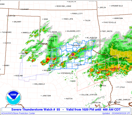
Tornado Watch for CENTRAL AND EASTERN ARKANSAS

TORNADO WATCH NUMBER 93
NWS STORM PREDICTION CENTER NORMAN OK
255 PM CDT TUE MAR 20 2012

THE NWS STORM PREDICTION CENTER HAS ISSUED A

TORNADO WATCH FOR PORTIONS OF

CENTRAL AND EASTERN ARKANSAS


EFFECTIVE THIS TUESDAY AFTERNOON AND EVENING FROM 255 PM UNTIL

1000 PM CDT.

TORNADOES...HAIL TO 1 INCH IN DIAMETER...THUNDERSTORM WIND GUSTS

TO 70 MPH...AND DANGEROUS LIGHTNING ARE POSSIBLE IN THESE AREAS.

THE TORNADO WATCH AREA IS APPROXIMATELY ALONG AND 55 STATUTE

MILES EAST AND WEST OF A LINE FROM 75 MILES NORTH NORTHEAST OF
LITTLE ROCK ARKANSAS TO 45 MILES SOUTH SOUTHWEST OF MONTICELLO
ARKANSAS. FOR A COMPLETE DEPICTION OF THE WATCH SEE THE
ASSOCIATED WATCH OUTLINE UPDATE (WOUS64 KWNS WOU3).

REMEMBER...A TORNADO WATCH MEANS CONDITIONS ARE FAVORABLE FOR

TORNADOES AND SEVERE THUNDERSTORMS IN AND CLOSE TO THE WATCH
AREA. PERSONS IN THESE AREAS SHOULD BE ON THE LOOKOUT FOR
THREATENING WEATHER CONDITIONS AND LISTEN FOR LATER STATEMENTS
AND POSSIBLE WARNINGS.

OTHER WATCH INFORMATION... CONTINUE...WW 92...

DISCUSSION...COMPOSITE OUTFLOW BOUNDARY CURRENTLY ROUGHLY BISECTING

AR WILL SERVE AS A FOCUS FOR INCREASING TSTM DEVELOPMENT THROUGH
LATE AFTERNOON/EARLY EVENING AS IT SLOWLY PROGRESSES EASTWARD...WITH
OTHER TSTMS POSSIBLE IN THE ADJACENT WARM SECTOR. A RELATIVELY
WARM/MOIST BOUNDARY LAYER IN CONJUNCTION WITH STRONG/DEEP SOUTHERLY
FLOW MAY YIELD STRONGER/SEVERE UPDRAFTS WITH THE QLCS...INCLUDING
EMBEDDED BOWING STRUCTURES AND A FEW SUPERCELLS. ISOLATED DAMAGING
WINDS AND A COUPLE OF TORNADOES MAY BE POSSIBLE IN ADDITION TO HEAVY
RAINFALL. Source

Tornado Touches Down Near San Antonio, Causing Damage And Injuries

(CNN) -- A suspected tornado touched down in south-central Texas on Monday, the National Weather Service said, as a slow-moving line of storms brought high winds, heavy rains and large hail as it swept eastward.

The Medina County, Texas, Sheriff's Office "received over 300 calls indicating there is damage or injuries" due to the storm, said a woman from the sheriff's office who identified herself only as Heather.

This came after one twister landed around 8 p.m. Monday near Natalia, a town of about 1,400 residents that is in the county.

"It struck us pretty hard," she said from the county, which is about 30 miles west of San Antonio. "At this point, we have unknown (amount) of injuries, but we have a lot of damage."

Charlie's Ice House, a bar in Devine, was in shambles after potent winds barreled through, ripping off its roof.

"It happened so fast and everyone was getting away from the doors ... and then it was over," said co-owner Marilyn Banks, adding that none of the 20 to 25 people inside suffered much more than a few scratches. Read More

One killed, two missing in Kashmir avalanche, India

Srinagar: One person was killed while two others were trapped under heaps of snow as two avalanches struck Gurez area near the Line of Control in Bandipora district of Kashmir.

A civilian vehicle with five persons on board including the driver were caught in the avalanches which struck at around 7 PM last evening on Kanzalwan road in Gurez, 124 kms from here, a defence spokesman said.

He said three persons were pulled out alive from the avalanche by a joint rescue team of civil administration and army while two persons were still trapped.

One of the rescued persons succumbed to injuries later, the spokesman said; adding efforts were on to trace the other two persons.

Air force helicopters have been kept on standby for evacuating the injured, an official of the Natural Disaster Management Cell said. He said heavy rains in the area were hampering the rescue efforts. Read More

New Zealand: North Island hammered by winds, Bringing down trees - More to come

Heavy winds battering the North Island have brought down trees and caused havoc on the roads as forecasters warn of more bad weather to come.

The storm that hammered Northland yesterday spread further south overnight, with heavy rain lashing the top of the North Island and winds gusting to 120km/h in the central and lower North Island.

The Fire Service said trees had fallen in Taranaki and the central North Island, while Gisborne police said there had been some surface flooding and felled trees south of the city.

Trees have blocked State Highway 5 between Taupo and Napier, and have also fallen on SH47 near Turangi and SH1 between Taupo and Turangi. Read More

Australian Floods: 20 people rescued in Cairns

Emergency workers have rescued more than 20 people from floodwaters after torrential downpours in far north Queensland.

A landslide on Monday at Ellis Beach cut-off the Captain Cook Highway, while several other major roads including the Gillies Highway have been blocked because of localised flooding, say police.

About 20 people had to be rescued on Monday night after becoming trapped between two causeways near Cairns, says the Department of Community Safety.

Another man had to be rescued from the back of his ute on Mission Beach early on Tuesday morning.

"SES units from Cairns, Gordonvale and Babinda have assisted in the rescue of about 20 people from floodwater in Little Mulgrave," the DCS told AAP.

"They were in cars trapped between two causeways where water flows quite rapidly," a DCS representative said.

"We also rescued a man from the back of a ute near Mission Beach.

"No one was injured." Read More